- WEATHER
Australia
- National
- New South Wales
- Victoria
- Queensland
- Western Australia
- South Australia
- Tasmania
- ACT
- Northern Territory
Long Range Forecasts
- WARNINGS
- RADAR
- SATELLITE
- MAPS & CHARTS
- LONG RANGE
Long Range Forecasts
- CLIMATE
Climate Indicators
- NEWS
Marine Weather
Byron Coast Marine Weather Overview
 navigate by marine district
Canberra Lakes
Sydney Inshore
Byron Coast
Macquarie Coast
Hunter Waters
Sydney Offshore
Illawarra
Batemans Coast
Coffs Coast
Eden Coast
 most recent warnings
NSW/ACT - Sat 04:10 ESTStrong Wind Warning for Hunter, Sydney, Illawarra and Batemans coasts. Cancellation for Eden Coast
View all current warnings
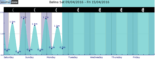
tides for Ballina
 forecast
Southerly 15/20 knots turning southeasterly during the day. Winds reaching up to 25 knots offshore south of Yamba in the late evening. Seas: Around 1 metre, increasing to 1/1.5 metres during the morning. Swell: Southerly around 1 metre inshore, increasing to 1/1.5 metres offshore south of Cape Byron. Outlook Sunday: Southeasterly 20/30 knots. Seas: 1.5/2 metres, increasing to 2/3 metres during the morning. Swell: South to southeasterly 1/1.5 metres inshore, increasing to 1.5/2 metres offshore north of Cape Byron around midday. Outlook Monday: Southeasterly 20/30 knots. Seas: 2/3 metres. Swell: Southeasterly 1.5/2 metres.
Issued Sat 04:10 ESTSeas: Up to 1.5m
Swell: Up to 1.5m, S
forecast winds
Saturday: SE 25 ktsSunday: SE 20/30 kts
Monday: SE 20/30 kts
- locations
- Yamba
- Alstonville
- Byron Bay
- Ballina
Sun & Moon Times
| first light | sunrise | sunset | last light | moon rise | moon set | moon phase | full moon | last quarter | new moon | first quarter |
|---|---|---|---|---|---|---|---|---|---|---|
|
05:44 EST |
06:08 EST |
17:22 EST |
17:46 EST |
15:31 EST |
03:26 EST |
|
Apr 24 |
May 1 |
May 8 |
May 15 |
A very wet weekend for southeast Qld, northeast NSW
11:48 AEST A prolonged rainfall event is set to bring large totals to parts of NSW and Qld from Saturday, with possible heavy falls and flooding. A low-pressure system in the Coral Sea, a deepening coastal trough and persistent easterlies will bring moisture-laden air into southeast Qld and northeast NSW will bring days of rainfall to the region. While there is not a drop of rain on the radar over southeast Qld and Northeast NSW on Friday morning, the mass of cloud associated with a low in the Coral Sea will enhance rainfall over the weekend.
- 10:07 AEST Southerly surges across the southeast
- 13:20 AEST Generation gone with the wind
- 11:29 AEST Devilishly dry in Tasmania
- 16:41 AEST Dubai deluge: a year's rainfall in a day


