- WEATHER
Australia
- National
- New South Wales
- Victoria
- Queensland
- Western Australia
- South Australia
- Tasmania
- ACT
- Northern Territory
Long Range Forecasts
- WARNINGS
- RADAR
- SATELLITE
- MAPS & CHARTS
- LONG RANGE
Long Range Forecasts
- CLIMATE
Climate Indicators
- NEWS
Marine Weather
Fraser Is Waters Marine Weather Overview
 |
Swell height | Districts with warnings | 3pm forecast wind |
 navigate by marine district
Moreton Bay
Southeast Gulf
Northeast Gulf
Peninsula Waters
North Tropical Waters
Tropical Waters
Central Coast
Capricornia
Southeast Coast
Hervey Bay
Fraser Is Waters
Great Barrier Reef
 most recent warnings
QLD - Fri 15:50 ESTStrong Wind Warning for Saturday for South East Gulf of Carpentaria, Hervey Bay & Mackay, Capricornia and K'gari coasts
View all current warnings
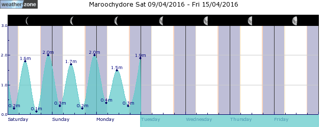
tides for Bundaberg
 forecast
Southeasterly 10/15 knots. Seas: Below 1 metre. Swell: Easterly around 1 metre. Outlook Saturday: Southeasterly 15/20 knots increasing to 20/25 knots in the morning. Winds reaching up to 30 knots during the afternoon and evening. Seas: Around 1 metre, increasing to 1.5/2.5 metres during the morning. Swell: Easterly around 1 metre. Outlook Sunday: Southeasterly 25/30 knots. Seas: 2/3 metres. Swell: Easterly 1.5 metres, tending southeasterly 1.5/2.5 metres during the morning. Outlook Monday: Southeasterly 30/35 knots. Seas: 3 metres. Swell: Southeasterly 2.5/3 metres.
Issued Fri 15:50 ESTSeas: Up to 1.0m
Swell: Up to 1.0m, E
forecast winds
Friday: SE 10/15 ktsSaturday: SE 30 kts
Sunday: SE 25/30 kts
Monday: SE 30/35 kts
- locations
- Double Is Point
- Rainbow Beach
- Maryborough
- Hervey Bay
- Bundaberg
Sun & Moon Times
| first light | sunrise | sunset | last light | moon set | moon rise | moon phase | full moon | last quarter | new moon | first quarter |
|---|---|---|---|---|---|---|---|---|---|---|
|
05:42 EST |
06:06 EST |
17:27 EST |
17:50 EST |
02:38 EST |
15:30 EST |
|
Apr 24 |
May 1 |
May 8 |
May 15 |
A very wet weekend for southeast Qld, northeast NSW
11:48 AEST A prolonged rainfall event is set to bring large totals to parts of NSW and Qld from Saturday, with possible heavy falls and flooding. A low-pressure system in the Coral Sea, a deepening coastal trough and persistent easterlies will bring moisture-laden air into southeast Qld and northeast NSW will bring days of rainfall to the region. While there is not a drop of rain on the radar over southeast Qld and Northeast NSW on Friday morning, the mass of cloud associated with a low in the Coral Sea will enhance rainfall over the weekend.
- 10:07 AEST Southerly surges across the southeast
- 13:20 AEST Generation gone with the wind
- 11:29 AEST Devilishly dry in Tasmania
- 16:41 AEST Dubai deluge: a year's rainfall in a day


