- WEATHER
Australia
- National
- New South Wales
- Victoria
- Queensland
- Western Australia
- South Australia
- Tasmania
- ACT
- Northern Territory
Long Range Forecasts
- WARNINGS
- RADAR
- SATELLITE
- MAPS & CHARTS
- LONG RANGE
Long Range Forecasts
- CLIMATE
Climate Indicators
- NEWS
Marine Weather
Fraser Is Waters Marine Weather Overview
 |
Swell height | Districts with warnings | 3pm forecast wind |
 navigate by marine district
Moreton Bay
Southeast Gulf
Northeast Gulf
Peninsula Waters
North Tropical Waters
Tropical Waters
Central Coast
Capricornia
Southeast Coast
Hervey Bay
Fraser Is Waters
Great Barrier Reef
 most recent warnings
QLD - Sat 15:50 ESTStrong Wind Warning for Hervey Bay & Mackay, Capricornia and K'gari coasts. Cancellation for South East Gulf of Carpentaria
View all current warnings
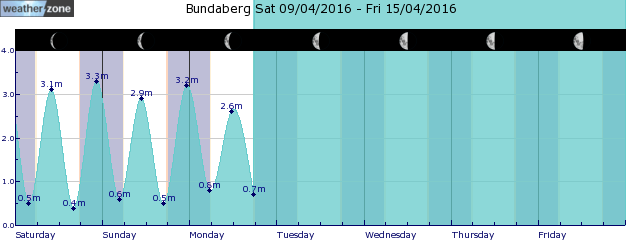
tides for Bundaberg
 forecast
Southeasterly 15/25 knots, reaching up to 30 knots offshore in the evening. Seas: 2/2.5 metres. Swell: Easterly around 1 metre. Outlook Sunday: Southeasterly 20/30 knots. Seas: 2/3 metres. Swell: East to southeasterly around 1 metre, increasing to 1/1.5 metres during the morning, then tending southeasterly 1.5/2 metres during the afternoon. Outlook Monday: Southeasterly 25/30 knots. Seas: 2.5/3 metres. Swell: Southeasterly 2/2.5 metres. Outlook Tuesday: Southeasterly 20/30 knots. Seas: 1.5/2.5 metres. Swell: Southeasterly 1.5/2.5 metres.
Issued Sat 15:50 ESTSeas: Up to 2.5m
Swell: Up to 1.0m, E
forecast winds
Saturday: SE 30 ktsSunday: SE 20/30 kts
Monday: SE 25/30 kts
Tuesday: SE 20/30 kts
- locations
- Double Is Point
- Rainbow Beach
- Maryborough
- Hervey Bay
- Bundaberg
Sun & Moon Times
| first light | sunrise | sunset | last light | moon set | moon rise | moon phase | full moon | last quarter | new moon | first quarter |
|---|---|---|---|---|---|---|---|---|---|---|
|
05:43 EST |
06:06 EST |
17:28 EST |
17:51 EST |
03:30 EST |
15:58 EST |
|
Apr 24 |
May 1 |
May 8 |
May 15 |
Winter is Coming: Chilly day for Sydney, rain pelts eastern seaboard
17:22 AEST Just as we forecast yesterday, a coastal trough has deepened along the NSW and southeast Qld coasts as a low in the Coral Sea continues to inch closer to Qld. The trough has brought some interesting weather to NSW in the past 36 hours or so, particularly along the coastal fringe, giving those New South Welshmen a “Stark” Game of Thrones reminder: winter is coming.
- 11:54 AEST We need to talk about drainage
- 11:48 AEST A very wet weekend for southeast Qld, northeast NSW
- 10:07 AEST Southerly surges across the southeast
- 13:20 AEST Generation gone with the wind


