- WEATHER
Australia
- National
- New South Wales
- Victoria
- Queensland
- Western Australia
- South Australia
- Tasmania
- ACT
- Northern Territory
Long Range Forecasts
- WARNINGS
- RADAR
- SATELLITE
- MAPS & CHARTS
- LONG RANGE
Long Range Forecasts
- CLIMATE
Climate Indicators
- NEWS
Marine Weather
Far Northwest Marine Weather Overview
 |
Swell height | Districts with warnings | 3pm forecast wind |
 navigate by marine district
Derwent Estuary
Hobart Waters
Inland Waters
Far Northwest
Central North
Northeast
Banks Strait
Upper East
Lower East
Southeast
Southwest
Central West
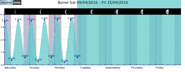
tides for Burnie
 forecast
Easterly 15/20 knots. Seas: Around 1 metre, increasing to 1/1.5 metres east of King Island during the morning. Swell: Southwesterly 1/2 metres, increasing to 2/3 metres during the morning. Outlook Thursday: Easterly 10/15 knots, reaching up to 20 knots inshore during the morning and early afternoon. Seas: Around 1 metre. Swell: Southwesterly 1.5/2.5 metres. Outlook Friday: Easterly 15/20 knots. Seas: 1/1.5 metres, increasing to 1.5/2 metres east of King Island during the morning. Swell: Southwesterly 1.5/2.5 metres.
Issued Wed 05:04 ESTSeas: Up to 1.5m
Swell: Up to 3.0m, SW
forecast winds
Wednesday: E 15/20 ktsThursday: E 20 kts
Friday: E 15/20 kts
- locations
- Cape Grim
- King Island
- Marrawah
- Smithton
Sun & Moon Times
| first light | sunrise | sunset | last light | moon set | moon rise | moon phase | first quarter | full moon | last quarter | new moon |
|---|---|---|---|---|---|---|---|---|---|---|
|
06:44 EST |
07:13 EST |
17:18 EST |
17:48 EST |
17:05 EST |
08:26 EST |
|
May 15 |
May 23 |
May 31 |
Jun 6 |
How severe thunderstorms impact energy infrastructure
09:23 AEST Earlier this year destructive thunderstorms and winds equivalent to a category two cyclone lashed Victoria, bending towers and toppling trees and poles. So, how can thunderstorms damage energy infrastructure, and are these events getting worse? This event occurred during mid-February 2024, when a strong cold front generated severe thunderstorms and localised wind gusts of 130km/h after a prolonged period of extreme heat.


