- WEATHER
Australia
- National
- New South Wales
- Victoria
- Queensland
- Western Australia
- South Australia
- Tasmania
- ACT
- Northern Territory
Long Range Forecasts
- WARNINGS
- RADAR
- SATELLITE
- MAPS & CHARTS
- LONG RANGE
Long Range Forecasts
- CLIMATE
Climate Indicators
- NEWS
Marine Weather
Wallal to Cape Preston Marine Weather Overview
 |
Swell height | Districts with warnings | 3pm forecast wind |
 navigate by marine district
Perth Local
Kuri Bay to Wallal
Wallal to Cape Preston
Cape Preston to Northwest Cape
Northwest Cape to Carnarvon
Carnarvon to Kalbarri
Kalbarri to Jurien Bay
Perth Offshore
Mandurah to Cape Leeuwin
Cape Leeuwin to Bremer Bay
Bremer Bay to Israelite Bay
Israelite Bay to Eucla
Kuri Bay to Wyndham
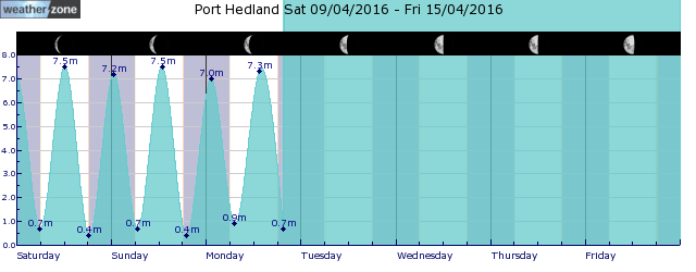
tides for Port Hedland
 forecast
South to southeasterly 10/15 knots tending east to southeasterly in the morning then becoming variable about 10 knots in the early afternoon. Seas: Around 1 metre. Swell: Westerly below 1 metre. Outlook Monday: Variable about 10 knots becoming northeast to southeasterly 10/15 knots in the morning then becoming variable about 10 knots in the late afternoon. Seas: Below 1 metre. Swell: Westerly below 1 metre. Outlook Tuesday: Variable about 10 knots becoming north to northeasterly 10/15 knots during the afternoon then becoming variable about 10 knots during the evening. Seas: Below 1 metre. Swell: Westerly below 1 metre.
Issued Sun 04:00 WSTSeas: Up to 1.0m
Swell: Up to 1.0m, W
forecast winds
Sunday: S/SE 10/15 ktsMonday: NE/SE 10/15 kts
Tuesday: N/NE 10/15 kts
- locations
- Pardoo
- Roebourne
- Karratha
- Port Hedland
Sun & Moon Times
| first light | sunrise | sunset | last light | moon set | moon rise | moon phase | new moon | first quarter | full moon | last quarter |
|---|---|---|---|---|---|---|---|---|---|---|
|
06:07 WST |
06:30 WST |
17:46 WST |
18:09 WST |
15:39 WST |
04:18 WST |
|
May 8 |
May 15 |
May 23 |
May 31 |
Intense Rainfall: Over 100mm in just 3 days over NSW
14:40 AEST The advance of a trough across the north and center of the state spread clouds across the state and, together with humid onshore winds, intensified instability in eastern NSW, leading to intense rainfall.


