- WEATHER
Australia
- National
- New South Wales
- Victoria
- Queensland
- Western Australia
- South Australia
- Tasmania
- ACT
- Northern Territory
Long Range Forecasts
- WARNINGS
- RADAR
- SATELLITE
- MAPS & CHARTS
- LONG RANGE
Long Range Forecasts
- CLIMATE
Climate Indicators
- NEWS
Marine Weather
Central North Marine Weather Overview
 navigate by marine district
Derwent Estuary
Hobart Waters
Inland Waters
Far Northwest
Central North
Northeast
Banks Strait
Upper East
Lower East
Southeast
Southwest
Central West
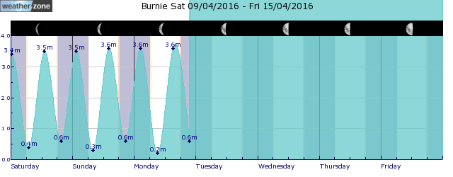
tides for Burnie
tides for Launceston
 forecast
Variable about 10 knots becoming northeast to southeasterly 10/15 knots in the late evening. Seas: Below 1 metre. Swell: Westerly below 1 metre. Outlook Monday: East to southeasterly 10/15 knots becoming east to northeasterly about 10 knots in the morning. Seas: Below 1 metre. Swell: Westerly below 1 metre. Outlook Tuesday: Variable about 10 knots. Seas: Below 0.5 metres. Swell: Westerly below 1 metre. Outlook Wednesday: Easterly 15/20 knots. Seas: Around 1 metre, increasing to 1/1.5 metres offshore during the morning. Swell: Westerly below 1 metre.
Issued Sun 16:05 ESTSeas: Up to 1.0m
Swell: Up to 1.0m, W
forecast winds
Sunday: NE/SE 10/15 ktsMonday: E/SE 10/15 kts
Tuesday: W 10 kts
Wednesday: E 15/20 kts
- locations
- Low Head
- Bridport
- Scottsdale
- Wynyard
- Burnie
- Devonport
- Launceston
Sun & Moon Times
| first light | sunrise | sunset | last light | moon set | moon rise | moon phase | new moon | first quarter | full moon | last quarter |
|---|---|---|---|---|---|---|---|---|---|---|
|
06:38 EST |
07:07 EST |
17:15 EST |
17:44 EST |
16:00 EST |
05:44 EST |
|
May 8 |
May 15 |
May 23 |
May 31 |
Intense Rainfall: Over 100mm in just 3 days over NSW
14:40 AEST The advance of a trough across the north and center of the state spread clouds across the state and, together with humid onshore winds, intensified instability in eastern NSW, leading to intense rainfall.


