- WEATHER
Australia
- National
- New South Wales
- Victoria
- Queensland
- Western Australia
- South Australia
- Tasmania
- ACT
- Northern Territory
Long Range Forecasts
- WARNINGS
- RADAR
- SATELLITE
- MAPS & CHARTS
- LONG RANGE
Long Range Forecasts
- CLIMATE
Climate Indicators
- NEWS
Marine Weather
Melbourne Bays Marine Weather Overview
 |
Swell height | Districts with warnings | 3pm forecast wind |
 navigate by marine district
Melbourne Bays
Western Bass Strait
Northern Bass Strait
Eastern Bass Strait
Gippsland Lakes
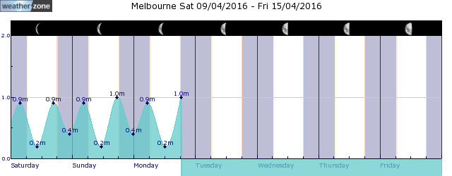
tides for Port Phillip Heads
tides for Geelong
tides for Melbourne
 forecast
South to southwesterly below 10 knots becoming easterly in the late evening. Seas: Below 0.5 metres. Outlook Sunday: Northeasterly below 10 knots becoming north to northwesterly early in the morning. Seas: Below 0.5 metres. Outlook Monday: Northwesterly 10/15 knots turning southwesterly 15/20 knots during the morning before becoming southerly 10/15 knots in the late evening. Seas: Below 1 metre, increasing to 1/1.5 metres west of Sandy Point during the morning. Outlook Tuesday: South to southeasterly 15/20 knots tending east to southeasterly below 10 knots during the evening. Seas: Below 1 metre, increasing to around 1 metre west of Sandy Point.
Issued Sat 16:40 ESTSeas: Up to 0.5m
Swell: Not available.
forecast winds
Saturday: S/SW 10 ktsSunday: NE 10 kts
Monday: SW 15/20 kts
Tuesday: S/SE 15/20 kts
- locations
- Avalon
- Cerberus
- Melbourne Airport
- Moorabbin
- Scoresby
- Viewbank
- Werribee
- Rhyll
- Cranbourne
- Frankston
- Melbourne
Sun & Moon Times
| first light | sunrise | sunset | last light | moon set | moon rise | moon phase | last quarter | new moon | first quarter | full moon |
|---|---|---|---|---|---|---|---|---|---|---|
|
06:32 EST |
07:00 EST |
17:37 EST |
18:04 EST |
11:12 EST |
20:16 EST |
|
May 1 |
May 8 |
May 15 |
May 23 |
Signs indicating Australia's cool season arrival
16:15 AEST Mere hours after our Total Lightning Network went quiet over the Australian continent, the Himawari satellite captured a clear, textbook snapshot of the arrival of Australia's cool season. A few distinguishing features should catch your eye: A band of cloud streaming over northern WA and towards the nation's interior A distinct clearing of cloud from most of the NT's Top End, and A band of cloud crossing to the south of WA Turns out, all three of these features point to one thing: winter is knocking at the door. Image: Himawari satellite imagery and mean sea level pressure (ECMWF) over Australia on the morning of Saturday, April 27th, 2024.


